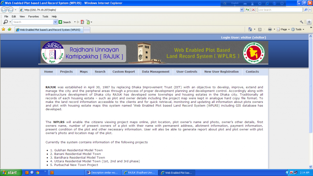
Web Enabled Plot Based Land Record System (WPLRS) with GIS features for different Township/Housing projects of RAJUK
Name of the Client: Rajdhani Unnayan Kartripakkha, Dhaka
Introduction
Traditionally, all records of each housing estates of RAJUK – such as plot and owner details, and project maps are kept in analogue hard copy format, which is very difficult to manage, store, and search, and is susceptible to damage. Moreover, the citizens have limited or poor access to these information. To overcome all these problems and to give better services to the citizens, in 2010-2012 we have developed a GIS integrated web based land record system named “Web Enabled Plot Based Land Record System (WPLRS)”. The System have GIS map layers of the project areas, a map attribute database connected with the Oracle database containing plot and owner related information. The GIS map layers, image of the owners and information about pot and owners are kept in a central Database which is centrally controlled by a software administrator. It is designed to display the project map layer on the screen and generate report and search plot information by clicking on the specific plot in the project map displayed.
The developed customized GIS software is a web based Land Record System which will enable the users to view the housing maps, plot location, plot and road details, owner’s detail with photo, present condition of the plot, information of allotment change, possession, payment, lease, transfer and mutation, mortgage, number of flat, flat owner, DCR number & page, plot etc. as necessary. This completed project is identical to the proposed project of KDA.
Overall Objective
To develop a web enabled plot based land record system for different Township/Housing Projects of RAJUK using GIS technology, updating/modification of existing Estate Management System (EMS) of RAJUK and linking the linking the oracle database of EMS with the developed GIS based program.
Specific Objectives
- Develop web enabled GIS based software
- Design the software to view the housing maps, plot location, plot and road details
- Design the software to view and generate report on owner’s detail with photo, present condition of the plot, information of allotment change, possession, payment, lease, transfer and mutation, mortgage, number of flat, flat owner, DCR number & page, plot etc. as necessary
- Generate GIS map layers of Housing Estates by digitizing paper maps using ArcGIS software
- Conduct GPS survey for georeferencinh with realworld coordinate and projection of the GIS map layers
- Scan and edit plot/flat owners photo and put them into the proposed GIS software database
- Collect/retrieve plot/flat owners data from the hard files of the plot/flat owners
- Enter the collected data into the software database
- Enter the plot attributes into the GIS polygon attribute table
- Assign different color to different polygon class to develop standard legend of the Housing Estate maps.
Major Activities/components completed in the project
- Developed GIS and Web based Software WPLRS
- Digitize Housing Estate Maps of
- Gulshan Residential Model Town
- Banani Residential Model Town
- Baridhara Residential Model Town
- Uttara Residential Model Town 1st Phase
- Uttara Residential Model Town 2nd Phase
- Uttara Residential Model Town 3rd Phase
- Purbachal New Town Project
- Development GIS attribute data of above housing estates
- Completed GPS survey of all housing estates
- Projected all maps into BTM real world coordinate system
- Collected plot and plot owner’s information from hard record file of NHA
- Entered collected data into software database
- Scanned plot owner’s photo and edited all collected photos
- Installing software into RAJUK server
- Given training on Software operation and GIS
Technical Features of the GIS and Web based Land Record Information System (LRGIS)
- Applications runs in LAN and WAN environment
- Can perform smart queries and produce customized reports.
- Integration with database is smooth and seamless.
- The software have spatial data access and display capabilities in web applications and services.
- The software have ability to generate map images, drill-down capability, thematic mapping, and other features that – generated on the server – will make the map images fully interactive on the client-side.
- The software has a GIS database to incorporate shape files of housing estate
- GIS map layers are georeferenced and projected in real world coordinate
- Theme features of the housing estate map data set were digitized using GIS software
vi) System Architecture/Software Platform Technology
| Operating System for both application Server & database server | Programming Language/ Technologies | Web/ Application server | Database |
| Windows 2008 | Java, C# , ArcGIS 9.2, ASPMAP, ASP.net | IIS | SQL Server |
Major Features
The major features of the LRGIS as follows:
- Customized software for digital data/information management, insert, update, retrieval, searching, printing and viewing map and plot information.
Options:
- Viewing detail information about plot and owner with photo by clicking on plots
- Viewing plot information by clicking on plot
- Selecting target plot from the project area maps to see owner information
- View map online with zoom in, zoom out, pan, scroll and detail view option
- Generating and printing report with owners photo by selecting individual plots
- Viewing plot information by search option
- Searching plot and owner information by different search options
- Viewing the list of projects by list project option and viewing map be selecting project name and then viewing other information by selecting plot
- Entering, updating and editing data/records/map/image